
How to Find Us...
The Fort Steele Campground is located in Southeastern British Columbia, approximately 10 minutes North of the City of Cranbrook, and only 2 km (1 mile) south of the Fort Steele Heritage Town, on Kelly Road. (Check the maps further down the page)
Our Street Address is:
335 Kelly Road, Fort Steele, BC
Our GPS co-ordinates are:
49 degrees 36.00 minutes North
115 degrees 38.52 minutes West
What3Words
///voiced.croak.senders
If you haven't heard of 'What3Words', check it out! Great way to find your way around the planet Earth! Extremely accurate - and "///voiced.croak.senders" will guide you to the front door of our check-in cabin.
From Cranbrook (Eastbound on Hwy 3):
Travel north and follow the signs toward Fort Steele Heritage town (Invermere, Radium, and Banff) by turning northbound on Hwy 93/95. About 5 minutes later, you will descend a VERY steep hill (8% grade)! Slow down on the hill, because at the very bottom, you turn right onto Kelly Road. Follow Kelly Road for 1 km (half a mile) into the campground. (If you cross the Kootenay River, you have gone too far.)
From Fernie, Sparwood, Crowsnest Pass, Lethbridge (Westbound on Hwy 3):
Before you get to Cranbrook, follow the signs toward Fort Steele Heritage town (Invermere, Radium, and Banff) by turning northbound on Hwy 93/95. About 5 minutes later, you will descend a VERY steep hill (8% grade)! Slow down on the hill, because at the very bottom, you turn right onto Kelly Road. Follow Kelly Road for 1 km (half a mile) into the campground. (If you cross the Kootenay River, you have gone too far.)
From Invermere, Radium, Banff and Golden (Southbound on Hwy 93/95):
Pass the Esso Campground (located right BESIDE the Highway at the Bull River Road on your left), then pass the Fort Steele Heritage Town on your right. You will cross over the Kootenay River. When you arrive at the base of the VERY steep hill which is straight ahead, turn left onto Kelly Road. Follow Kelly Road for 1 km (half a mile) into the campground.
Map 1: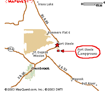
Map 2:
